Language
Low-Altitude Intelligent Connectivity for Digital Skyway
Release Date:2026-01-22
By Ren Tao, Wang Qinghong
Driven by supportive policies, expanding application scenarios, and cutting-edge technologies, China’s low-altitude economy is transitioning from conceptual exploration to large-scale development. As a diversified business cluster born from the deep integration of the general aviation and unmanned aerial vehicle (UAV) industries, it supports innovative applications such as aerial logistics, low-altitude tourism, and emergency rescue. With strong growth momentum, this sector is gradually becoming a new driver for the national economy.
The concept of the "low-altitude economy" was first introduced in China’s National Comprehensive Three-Dimensional Transportation Network Planning Outline in February 2021 and was later identified in the 2024 Government Work Report as a new growth engine. Since then, nearly 30 provinces have introduced supportive policies. According to the Research Report on China's Low-Altitude Economic Development (2024) by the CCID Consulting, the sector is expected to surpass one trillion yuan in scale by 2026, entering a fast development phase.
Safety: Key to the Low-Altitude Economy
The low-altitude economy encompasses multiple fields such as general aviation, UAV logistics and delivery, low-altitude tourism, and emergency rescue, boasting broad development prospects. However, with increasingly frequent low-altitude flight activities and a complex flight environment, safety risks have risen significantly. It is urgent to establish an advanced regulatory system to ensure the safety of low-altitude flights.
However, traditional regulatory methods face numerous limitations. For instance, time difference of arrival (TDOA) spectrum detection can only monitor specific frequency bands, suffering from a high false alarm rate and low accuracy. Low-altitude radars have issues such as near-range blind spots and susceptibility to interference, making network formation difficult, all of which constrain the large-scale development of the low-altitude economy.
The integrated communication, sensing, computing, and intelligence (ICSCI), emerging in the 5G-A phase, utilizes electromagnetic waves emitted by communication base stations. This technology not only enables communication functions but also detects flying objects in the surrounding environment by analyzing reflected signals, assisting regulatory authorities in managing low-altitude aircraft.
ICSCI Empowers Low-Altitude Supervision
ZTE's ICSCI technology enables precise, full-domain perception of aerial targets and easily distinguishes target categories and aircraft identities, supporting "precise detection, clear categorization, and unambiguous identification" for low-altitude supervision.
Precise Detection
In complex environments, such as dense urban areas, a large number of strong reflected signals can lead to false alarms and missed detections. Leveraging deep learning algorithms, ZTE's ICSCI technology extracts features from echo data for clutter suppression and target recognition. Through extensive training data—including radar echo data containing both clutter and target signals—it learns the distinct feature patterns of clutter and targets, effectively separating them and reducing false alarm and missed detection rates.
Clear Categorization
AI enables accurate classification of diverse low-altitude targets such as UAVs, birds, and balloons through multi-modal data integration and deep learning models (Fig. 1).
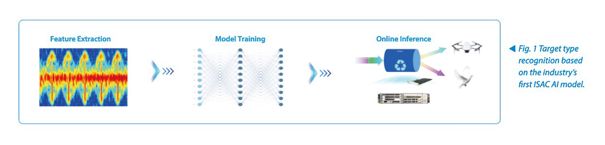
First, multi-dimensional feature extraction is performed:
- Behavioral features: Different targets exhibit distinct motion characteristics—for instance, birds follow irregular flight trajectories;
- Physical features: Targets differ in radar cross-section (RCS) and reflected signal intensity;
- Motion features: Targets move at different speeds, with UAV rotors and bird wingbeats generating distinct micro-Doppler effects;
- Polarization features: Different target types display unique reflection characteristics in response to sensing signals of varying polarizations. By transmitting and receiving sensing signals with different polarization combinations and analyzing the polarization scattering matrix (PSM) of the echoes, the polarization features of targets can be obtained to identify their types.
Then, neural network models, such as LMP and LSTM, are utilized to extract spatial features from echoes, capture dynamic variation features in echo sequences, and learn the characteristics of different aerial targets for precise target recognition.
Unambiguous Identification
ZTE's ICSCI Technology, built on three core judgment capabilities—service feature judgment, wireless feature judgment, and terminal location judgment—can accurately identify UAV communication modules and their corresponding phone numbers, which are reported to the UAV management and control platform in real time. The platform classifies unregistered numbers as illegal UAVs and instructs the mobile communication system to implement network-based control over them, expelling illegal UAVs. Among these capabilities, service feature judgment leverages ZTE's DeepEdge functionality to rapidly identify UAV data streams (such as video transmission and flight control data) through a fingerprint feature library, enabling differentiation between UAVs and mobile phone terminals.
ZTE Actively Advances the Commercialization of the Low-Altitude Economy
Based on its ICSCI technology, ZTE has collaborated with operators and third-party partners to launch over 100 commercial and pilot low-altitude projects worldwide, covering diverse application scenarios, such as low-altitude logistics, low-altitude inspection, and low-altitude security in key facilities.
At the Beijing Yanqing UAV Industrial Park, ZTE has successfully conducted multi-type target recognition tests based on AI models, leveraging a large-scale, contiguous networking environment built on ICSCI technology. These tests enable birds to be "detected accurately and identified unambiguously," transforming passive prevention and control into proactive recognition—providing a "new solution" to bird strikes, a long-standing challenge.
In Hengqin, Zhuhai, based on the industry's largest-scale ICSCI network, the system excelled as an "Aerial Police" during the 25th anniversary celebration of Macao's return to China. It conducted 24/7 detection of UAVs and other aerial objects in the low-altitude airspace, supporting UAV security operations.
The low-altitude economy will not only transform mobility, but also exert a profound impact on daily lives and manufacturing models. ZTE remains committed to deepening its engagement in the low-altitude economy sector. Leveraging ICSCI technology, a digital “Skyway” is being built to enable the high-quality development of the low-altitude economy.