Language
mmWave ISAC: Pioneering a New Era in Water Area Development
Release Date:2025-03-27
By Hai Zhenkun, Wang Qinghong
hina is rich in water resources, with over 500,000 rivers totaling 430,000 kilometers. Among them, approximately 1,500 rivers cover an area exceeding 1,000 square kilometers. The country also has an 18,000-kilometer coastline and a total maritime area of over 4.73 million square kilometers. These vast water resources provide significant opportunities for industries such as shipping, fisheries, and tourism. In 2023, China’s marine economy output surpassed 10 trillion yuan. With the rapid development of next-generation information and communication technologies, such as 5G, information infrastructure and digital applications in aquatic sectors have accelerated. Traditional water area industries are undergoing digital, green, and intelligent upgrades, giving rise to new industries, business models, and innovations.
Waterway Safety Urgently Requires Cost-Effective Regulatory Solutions
China’s rapid development in the water economy calls for effective and economical solutions to ensure safety and compliance.
In waterway transportation, smart ports require comprehensive monitoring of vessels, cargo, and other operational elements to ensure waterway safety and regulatory compliance. With the continued growth of tourism, the number of lakes has been steadily increasing, requiring effective management, such as enforcing fishing bans during designated periods.
Current monitoring of waterways primarily rely on four systems: automatic identification system (AIS), vessel traffic services (VTS), closed circuit television (CCTV), and BeiDou navigation satellite system (BDS). These systems depend on vessels receiving GPS or Beidou satellite positioning signals and actively reporting their location via communication networks. However, adverse weather conditions, such as heavy rain or fog, can impair satellite positioning accuracy. Additionally, vessels without communication or positioning functions and floating debris on the water surface often go undetected, as active reporting technologies can’t effectively identify such situations.
In maritime regulation, monitoring focuses on three key scenarios: nearshore law enforcement, illegal fishing detection, and unauthorized intrusion prevention. Vessels engaged in illegal activities generally avoid connecting to GPS systems, making monitoring more challenging.
Current maritime surveillance predominantly relies on radar systems combined with infrared cameras, but these methods have significant limitations, such as high deployment costs, fragmented network coverage, and weak real-time performance. Infrared thermal imaging technology, which operates within the 750–2500 nm wavelength range, cannot penetrate opaque obstacles, and its detection range is constrained by the curvature of the sea surface. Additionally, deploying optical cables for data transmission is difficult and costly.
Similarly, shore-based radar systems monitor isolated islands, ports, and offshore drilling platforms, detecting small vessels within a 10 km range. However, the deployment cost is high and full-scenario coverage is diffcult. Moreover, data transmission via third-party interfaces often results in delays. As a result, by the time an alert is received, the vessel may have already left the monitored area. Mobile surveillance ships integrate multiple sensing technologies but are the most expensive option and cannot provide 24/7 continuous monitoring, limiting their use to high-priority maritime zones.
mmWave ISAC Empowers Water Area Regulation
Millimeter wave integrated sensing and communication (mmWave ISAC) technology offers significant potential for water area monitoring and regulation. By integrating communication, sensing, and computation within the mmWave spectrum, ISAC enhances resource utilization and sensing precision. Compared to traditional systems, ISAC reduces the need for additional sensing hardware, lowering costs and energy consumption, aligning with green and sustainable development goals. mmWave, with its rich bandwidth and high-speed transmission capabilities, enables precise distance measurement, speed detection, and real-time positioning. In dynamic water area scenarios, ISAC supports accurate vessel trajectory tracking and comprehensive monitoring of surface activities. Additionally, ISAC’s networkable design ensures continuous and seamless coverage under various environmental conditions, making it suitable for diverse regulatory requirements.
ZTE Actively Promotes Research and Application of mmWave ISAC in Water Areas
ZTE has taken a leading role in the development and application of ISAC technology for water areas. It introduced the industry’s first monostatic mmWave ISAC AAU, which integrates sensing signal transmission and reception into a single unit. ZTE’s ISAC AAU employs a unique combination of continuous and pulsed waves, achieving high precision and long-range sensing capabilities. Real-time signal processing and trajectory analysis are performed using BBU computing, enabling fast and accurate data reporting with low latency. This cost-effective system offers a reliable solution for extensive water area monitoring.
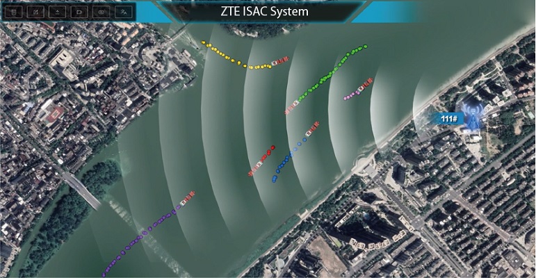
ZTE has explored the application of mmWave ISAC technology in waterway regulation. For instance, in the Huangpu River, ZTE deployed ISAC technology for real-time monitoring of vessel trajectories, speeds, and other data, even in foggy and rainy conditions. This significantly enhances waterway safety and vessel management efficiency.
In the Wuhan section of the Yangtze River, ZTE has built a waterway electronic fence system that allows precise detection and real-time alerts for vessels illegally entering restricted zones, ensuring legal waterway safety. Additionally, in the Sun Island area of Harbin, ZTE implemented a system for synchronous detection of multiple vessels, achieving millisecond-level sensing delay to support collision avoidance, laying the foundation for creating a high-tech“Smart Winter Games.”
As mmWave technology evolves, ISAC is expected to deliver expanded coverage, reduced costs, and simplified deployment. The deployment of ISAC systems will unlock greater value from 5G networks, enabling multi-functional applications and promoting sustainable development in water area management.
Related Articles