Language
mmWave ISAC:Driving Low-Altitude Economy
Release Date:2025-03-26
By Ren Tao
Driven by supportive policies, the continuous expansion of application scenarios, and the rapid evolution of technology, the low-altitude economy—an ecosystem of diverse new industries and business models fueled by the growth of general aviation and unmanned aerial vehicle (UAV) industries—is emerging as a new engine for China's economic growth.
The Rise of the Low-Altitude Economy
The concept of the "low-altitude economy" was first introduced in China’s "National Comprehensive Three-dimensional Transportation Network Planning Outline" in February 2021. In March 2024, the Government Work Report released at the annual "two sessions" meetings proposed proactively fostering new growth engines such as bio-manufacturing, commercial aerospace, and the low-altitude economy. This marked the first time the low-altitude economy was mentioned in the Government Work Report and categorized as part of new quality productive forces.
Since 2024, nearly 30 provinces have incorporated the development of the low-altitude economy into their government work reports or issued related policies. The favorable national policies have created an environment conductive to the development of the low-altitude economy. According to the "China Low-Altitude Economy Development Research Report (2024)" released by the CCID Research Institute of the Ministry of Industry and Information Technology, the scale of China's low-altitude economy reached 505.95 billion yuan in 2023, and it is expected to exceed 1 trillion yuan by 2026.
Key Requirements of the Low-Altitude Economy for Low-Altitude Networks
With the gradual maturation of low-altitude flight technologies, such as drones and electric vertical take-off and landing (eVTOL) vehicles, the low-altitude economy has expanded beyond traditional air transportation into diverse fields such as logistics, emergency rescue, aerial inspection, and aerial tourism. However, this diversification has also brought stricter requirements and challenges to network infrastructure, particularly in low-altitude communications and low-altitude surveillance.
In low-altitude communications, the core requirements focus on data transmission and video transmission between UAVs and ground stations. For data transmission, the network must ensure continuous, stable, highly reliable, and low-latency communication during low-altitude operations, enabling UAVs to receive operational instructions while allowing ground stations to track the flight status of UAVs in real-time and provide immediate feedback.
Video transmission, on the other hand, emphasizes the efficient transmission of high-definition images and videos captured by UAV cameras to the ground. This requires high uplink bandwidth; for example, the uplink rate requirement for 1080P videos is approximately 5 Mbps, while for 4K videos, it can reach up to 25 Mbps.
In low-altitude surveillance, it is necessary to monitor and provide services for cooperative UAVs to ensure orderly and controllable flight, as well as to detect and counteract non-cooperative UAVs to guarantee airspace safety.
However, traditional low-altitude communication and surveillance technologies face numerous limitations, such as limited coverage for point-to-point communication, insufficient positioning accuracy in spectrum monitoring, and the difficulty of continuously networking low-altitude radars, all of which restrict the in-depth development of the low-altitude economy. The emergence of integrated sensing and communication (ISAC) technology in the 5G-Advanced (5G-A) phase has become a key solution to address these issues.
mmWave ISAC: Enabling Ubiquitous Connectivity and Easy Management in Low-Altitude Spaces
ISAC achieves a deep integration of communication and sensing technologies. In traditional technological architectures, communication and sensing are two distinct functional domains. Communication primarily handles the transmission of information, serving as the core function of 4G/5G cellular networks. In contrast, sensing focuses on monitoring and identifying the surrounding environment and objects, typically undertaken by sensing devices such as radars and cameras. The introduction of ISAC in the 5G-A phase equips communication base stations with unprecedented "visual" capabilities, similar to radar-like object detection and sensing functions.
The core of the ISAC base station lies in its dual capabilities of "communication" and "sensing," both realized using electromagnetic waves within the same frequency band. Specifically, the communication function modulates electromagnetic waves to carry and transmit information such as voice and data. In contrast, the sensing function focuses on analyzing echo signals of electromagnetic waves to accurately locate, measure distance, and determine the speed of target objects. This breakthrough enables communication base stations not only to transmit information but also to "see" and understand their surroundings, significantly broadening their application scenarios.
When selecting the frequency band for ISAC technology, millimeter wave (mmWave) has emerged as an ideal choice for achieving high-precision detection, due to its superior bandwidth advantages and beam narrowing characteristics. The large bandwidth of mmWave enables high-speed information transmission, while the narrow beamwidth facilitates more precise detection and positioning, bringing revolutionary changes to drone communication and surveillance in the low-altitude economy.
Key Technology of ZTE's Integrated Sensing, Communication, Computing and Intelligence
ZTE, with its profound expertise in cellular communication technology and exceptional innovative capabilities, has successfully launched multiple industry-leading core technologies for ISAC, leading industry development and providing strong technical support for the growth of the low-altitude economy.
In communication technology, to address challenges in low-altitude communication, such as severe interference, frequent handovers, and network jitter, ZTE has introduced the user-centric dynamic, distributed, and deterministic extremely large antenna array (D3-ELAA) solution. This solution leverages dynamic coordination and distributed beamforming technologies to ensure stability and certainty in user experience, successfully pushing the boundaries of cellular networks and achieving ultra-stable communication in low-altitude environments. It provides reliable communication for low-altitude flying devices, such as drones.
In sensing technology, ZTE has also demonstrated its powerful innovative capabilities. To address the issue of insufficient coverage height of traditional base stations, ZTE has launched the industry's first monostatic ISAC AAU with a vertical scanning angle exceeding 60 degrees. Furthermore, to tackle the tradeoff between long-distance sensing and close-range blind zones in traditional radar technology, ZTE has creatively proposed dual-waveform intelligent sensing technology. By transmitting pulsed and continuous waves in a time-division manner, this technology achieves a perfect balance between long-distance sensing and close-range, blind-zone-free operation, further enhancing the practicality of sensing technology.
Building on basic sensing capabilities, ZTE has taken a step further by introducing an intelligent computing board into the baseband unit (BBU) of the base station, equipping it with native AI capabilities. This innovative measure enables the base station to perform advanced functions such as classifying and identifying sensing targets like drones and birds, as well as recognizing the identities of network-connected drones. This provides more precise and efficient technical support for low-altitude management and control.
ZTE Actively Drives Commercial Applications in the Low-Altitude Economy
Currently, ZTE has collaborated with operators and third-party partners to complete over 80 low-altitude communication and sensing pilot projects in 25 provinces and municipalities, covering a wide range of application scenarios such as logistics and delivery, low-altitude inspection, and low-altitude security in critical facilities.
At the Talent Park in Nanshan District, Shenzhen, ZTE has completed the construction of 5G-A ISAC base stations, successfully validating applications such as electronic fence intrusion warning for low-altitude security, multi-target drone trajectory tracking, and route sensing for Meituan’s food delivery drones. These applications essentially cover the full range of low-altitude sensing scenarios.
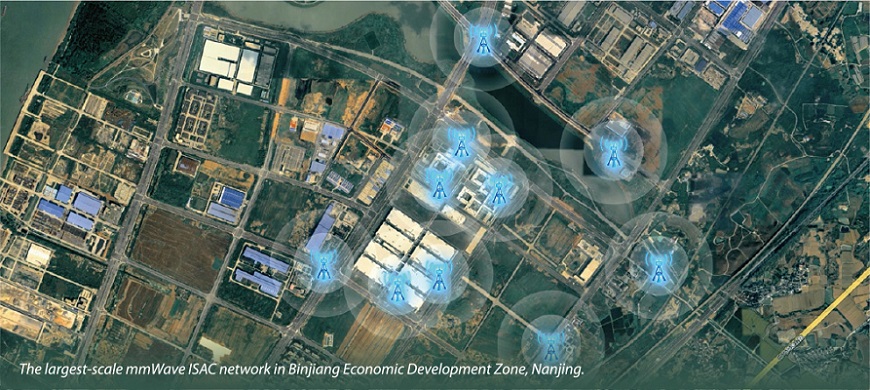
In Nanjing Binjiang Economic Development Zone, ZTE has implemented the largest-scale 5G-A mmWave ISAC network for low-altitude applications, deploying 10 mmWave ISAC base stations in a coordinated manner to cover 10 square kilometers of low-altitude space above Binjiang. Various low-altitude communication and sensing services have been validated, including simulations of complex air routes, low-altitude logistics feeder routes, and low-altitude air quality monitoring. This represents a significant step towards commercialization of 5G-A ISAC technology.
In Anyang, Henan Province, a large-scale UAV fleet test for 5G-A low-altitude communication and sensing was successfully completed. During the test, a fleet of 20 UAVs flew simultaneously, and multiple rounds of precise detection were conducted using mmWave ISAC base stations, with zero missed detections. This validates the stability and reliability of 5G-A mmWave low-altitude ISAC technology in complex environments, paving the way for future practical applications.
Looking ahead, ZTE will continue to deepen its involvement in the low-altitude economy. This sector will not only revolutionize transportation but also profoundly impact daily life and manufacturing processes. In this journey, 5G-A ISAC technology will pave the digital "skyway" for the high-quality development of the low-altitude economy, safeguarding it and helping to create a brilliant future.
Related Articles